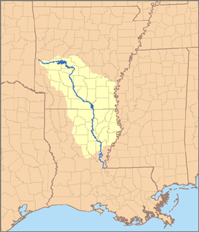
One of the craziest things from this end is what the other end looks like. Up here the Ouachita is a smallish river with rocks and rapids and lakes wending through a hilly forested landscape.
Down there, the Ouachita is a commercial thoroughfare with drawbridges or flyovers for commerce, crawling over flat, swampy land surrounded by crops, sand pits, paper plants, and other commercial uses. The differences in the environment as we travel down river will be huge.
We stopped in Monroe/West Monroe for dinner, the first time I've gotten off of I-20 right there. Its a cute little place, with a downtown that is oriented around the river. However I-20 is the main commercial route, so the town has sprawled out in a common American way. However, there was a "First Thursday" gathering at the good looking Art Galleries in Monroe, and West Monroe has styled out it downtown as an open air Antiques Mall. No cotton barges being loaded on the waterfront, but we did see a huge intermodal container train cross the Ouachita on Monroe'e famous steel truss drawbridge.
Speaking of Intermodal, I was talking to an ACE Engineer the other day who said that there are plans to put in a BIG intermodal facility near Wilmar AR, on the future I-69 Corridor. It would take containers of of barges and set them on trucks or trains, and vice-versa. Inland facilities like this will bring international shipping into a growing area of Arkansas. Exciting.
Feb. 6th, 2009
In April we'll be floating the Upper Ouachita from the Pine Ridge put in to the Headwaters of Lake Ouachita.
The Mayday May First Artwalk Friday Ouachita Float Tour Extravaganza will be held May First at Low Key Arts. The next day we'll hit the water and kick off a month long tour down the lower Ouachita River. We'll run into the Black and the Red and end up at Old River Control on the Mississippi, or as close as we can get.
Stay tuned here as we ramp our project up. Join us on our Ouachita Maydays Float Tour.
Check out the Maps link for the big picture
Feb. 3, 2009
• Home